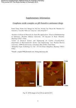
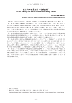
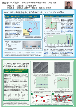
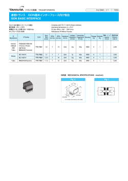
Technical Reports of the MRI,No。371999
WATER MASS ANALYSIS
3.Weste]m Nortk Pacific
3.1Water masses between Min且anao an−New Guinea
:Kashino,Aoyama,Kawano,Hendia而,Syaefu面n,Amntasena,Mmeyama,a面Watambe(1996)
In the westem equatorial Pacific,particularly in the southem PhHippine Sea,there is an area caUed“water
mass crossroads”where several water masses丘om the northem and.southern hemispheres meet.
Kashino6齢1.(1996)investigated water masses between Mindanao and New Guinea,using hydrographic
data,during two R/V働加πWOCE expeditions conducted in October1992and February1994by the Japan
Marine Science and Technology Center(JAMSTEC)to understand the Indonesian through旦ow,which probably
plays an important role in the global ocean circulation。It is important to i(ientify which water masses enter the、
In(lonesian Seas from the Pacific.
Conclusions are as follows:
1.South Paci丘c Tropical Water(SPTW),with a salinity maximum around25.0σθreaches north of Morotai
Island (Fig.96−18).
2.Antarctic Intemediate Water(AAIW),with a salinity minimum around27.2σθand high oxygen(>100
μmol/kg),exists in the southwestem area of the southemmost PhHippine Sea(Fig.96−19).
3.North Paci五c Tropical Water and the remnant of the North Paci丘c Intemediate Water originating in the
North Pacific retum from the Celebes/Maluku Seas with the low salinity water via the northeastward fしow
between Talaud Islands and Morotai Island.They found that this northeastward flow,which was shown to
existintheupper100mbyLukasασ1.(1991),extendedtoatleastadepthof300−400m.Thisfin(iing
suggests that retroflection of the Mindanao Cu皿ent(MC〉occurs in the Celebes Sea.
4.The New Guinea Coastal Undercurrent,transporting SPTW and AAIW from the southem hemisphere,is
divided into at least two parts because the retro皿ection of the MC prevents its shallow part from reaching
farther north;the shallower SPTW.tums eastward as a source of the North Equatorial Countercurrent and
retro且ects toward the southeast.AAIW and the lower part ofSPTW且ow northward and appear to be linked
to the Mindanao Undercurrent.
一50一
Technical Reports of the MRI,No.371999
Solinity (PSS−78)
Φ
コ
⊃
だ 40N
ヲ
〇
一
、
、 暖参
60N
翼 髭
︸ 陽磁
80N
Solinity(PSS−78)
a
b
80N
’
翼 寓 風 翼 翼・罵 瓢 翼軍{
60N
・ “
Φ
コ
コ
ヲ 40N
Po
、
」
20N
20N
oo
O。
1560E
1240E 1260E 1280E 1500E 132。E 1540E 156。E
124。E 126。E 1280E 1500E 132。E 154。E
Longltude
Longitude
Contouring on SurfGce STH = 25.OOO
Contouring on Surfoce STH = 25:000
Fig.96−18 Salinity(1istributionsatsurfaceσθ=25.0(luring(a) κ吻o WOCE I and(b)K吻o WOCE II. Contour
interva1:0.1PSS.
O×ygen(μmol/kg)
SiIicqte(μmoi/kg)
b
a
身
60N
診
80N
←も
80N
’
ぴ阪
’
\・/〒
6。N
Φ
㊤
で
コ
} 4。N
署
℃
コ
ー 4。N
署
、
o
J
o
」
20N
20N
0。
O。
124。E 126。E 1280E 1300E 132。E 154。E
136。E
Longitude
124。E 126。E 128。E’130。E 152・E 134。E
Longitude
156。E
Contouring on Surfqce STH = 27200
Contouring on Surfoce STH = 27。200
AccelerotionPotentiol(J/kg)
C
80N
i齢寓ノ
,購
6。N
o
u⊃
一 40N
P
O
J
、
20N
oo
124。E 1260E 1280E 1500E 132。E 1540E 1360E
七〇ngitude
Contouring on Surfoce STH = 27.200
Fig.96−19
(a)Dissolve(10xygen,(b)siHcate,and(c)acceleration potential rela[ive to1500(lbar on the suぜaceσθ=
27.2during K吻o WOCE II.Contour intervals are5.0μmol/kg,2.0μmo1/kg,and O・1J/kg・
一51一
Technical Reports of the MRI,No371999
3.2Prelimimry stu−y of in the mrth centml Japan Sea temperature stmcture
Hirose,Hong,an−Miyao(1996)
The north Japan sea is sig面cant because of the formation of upPer Japan Sea Proper Water(JSPW),
which occupies most of the deep waters in the Japan Sea and is extremely homogeneous in salinity,
temperature,an(1higher oxygen in winter due to d.eep convection.Little observational data has been collected,
however,especially in winter.
In March1994,a Japan−Korea−Russia Expedition was conducted in the north central Japan Seα,the main
purpose of which was to(ietermine the ra(lioactive contamination of seawater,biota,and se(1iment from
radioactive waste(1umping by Russia(and the former USSR).During the expedition,Hirose6∫σ1.(1996)
conducted CTD and XBT measurements to d.etermine hy(irographic features of the area surveyed(Fig.96−20).
Water mass in early sp血g in the north central Japan Sea(north of400N)was characterized as cold(1ess
than2.5。C)an(i salinity−homogeneous(34.07±0.02).Vertical profnes of seawater temperature suggest that the
water mass can be divided into at least two parts:surface water and JSPW.The spatial distributions ofseawater
temperature suggest that an anticyclonic eddy coupled with a cyclonic eddy was present in the north central
Japan Sea(Fig.96−21).Hy(1rographic information is important to un(ierstanding the distribution of ra(1ionuclides
in the north central Japan Sea.
131●
43●
132●
133●
融
瞬 ’
134●
135●
輔
N7
N1
N2
X1
41●
う∂り∠
N6
NX
42●
N5
N4
BG1
X3
X4
X5
40●
39●
Fig。96−20 Track and samp㎞g points in central Jal)an Sea.
一52一
Technical Reports of the MRI,No.371999
(b)
(a)
ド 133
Om
Om
N6 ×1 N5
ヤじ
\一_−、、 1.2受
134 E
N7 NI N2 ×2
、、1、
\\、
繁§警
、
、
、
、
、
、
、
、
、、、、 、、、、 、一、、
1.0
、・\、、’、一超藁
\、\
\、 \ 1.0
α6、 \・t’\Q8’・
誉濠
200
200
へ0.8
0.4
/
\
、 、
0.6
400
、、、
400
\α4
\\
600
600
(c) 42。
Om
41●
40N
ゆ
N皇X2 墜4ק
2.O
200
400
600
(
Fig。96−21Seawatertemperaturecrosssectionsfromsurfaceto600mdepth.a:N6−N5,b:N7−X2,c:N3−X5.
一53一
© Copyright 2026 ExpyDoc