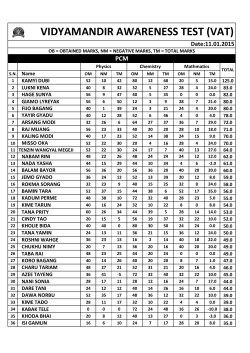
Buoys, marks and beacons
Traffic lights and signs guide drivers on the roads.
Buoys, beacons and navigation lights do the same on
the water.
In Queensland, the system of buoys, beacons, marks and lights
used is compliant with the International Association of Marine
Aids to Navigation and Lighthouse Authorities (IALA) Buoyage
System ‘A’. Each type of mark has its own colour, shape, top
mark and light combination.
To navigate safely, you need to know each mark and its meaning.
Lateral marks
Lateral marks show the port (left) and starboard (right) sides of
navigable waters or channels.
A port mark is red with a can-like shape and displays a red flashing
light at night (when lit). A starboard mark is green with a cone-like
shape and displays a green flashing light at night (when lit).
When port and starboard lateral marks are opposite each other,
travel between them. When there is a single lateral mark, the
safe side to pass depends on the direction of travel (or buoyage).
This is shown on charts by the symbol:
When travelling upstream or away from the sea:
• keep port (red) marks on your port-hand side (left)
• keep starboard (green) marks on your starboard
hand side (right).
When travelling downstream
or towards the sea:
• keep port (red) marks on your starboard-hand side (right)
• keep starboard (green) marks on your port-hand side (left).
Cardinal marks
North cardinal mark
Cardinal marks show where the deepest and safest water is
by using a compass. They can mark:
The top cones point up or North, showing there is safe water
to the North of the mark.
• where to find the deepest water in an area
East cardinal mark
• the safest side to pass a danger
• a feature in a channel (for example, a bend, junction or
the end of a shoal).
Cardinal marks have black and yellow bands with black
double cones on top showing the different compass
directions that identifies the safest and deepest water.
The top cones are in the shape of an egg, showing there is
safe water to the East of the mark. To remember this, think of
‘e’ for egg and for East.
South cardinal mark
The top cones point down or South, showing there is safe
water to the South of the mark.
West cardinal mark
The top cones make the shape of a wine glass, showing there
is safe water to the West of the mark. To remember this, think
of ‘w’ for wine glass and for West.
North
12
(continuous)
West
9
Light 3 East
F
Flashe
s
(followed by one long flash)
6
South
At night, each type of cardinal mark has a flashing white light
with different groupings of flashes (continuous, or groups
of 3, 6 or 9). To remember each type, think of a compass
face with the numbers of a clock marked on it beside each
direction:
• 3 (quick or very quick) flashes for East
• 6 (quick or very quick) flashes followed by a long flash for
South
• 9 (quick or very quick) flashes for West
• continual (quick or very quick) flashes for North.
Isolated danger marks
Special marks
Isolated danger marks show where there is an isolated
danger that has navigable water all round it – but don’t pass
too close.
Special marks show a special area or feature. For example, to
show that a channel divides or to mark cables or pipelines.
Isolated danger marks are black with 1 or more red horizontal
bands and 2 spheres as the top mark.
At night, the white light flashes in groups of 2. To remember
isolated danger marks, think of 2 flashes of light with 2
spheres as the top marks.
They can also mark a channel within a channel. For example,
a channel for deep draught ships in a wide river or bay where
the limits of the channel for normal navigation are marked by
red and green lateral buoys or beacons.
The direction to travel around a special mark is usually
referred to or shown on charts.
Special marks are yellow and sometimes have a yellow X as
the top mark.
At night, the flashing light is yellow.
Safe water marks
Safe water marks show that there is navigable water all
around the mark. For example, fairway, mid-channel or
landfall marks.
Safe water marks have red and white vertical stripes with a
single red sphere as the top mark.
At night, a single white light shows 1 long flash every 10
seconds. To remember safe water marks, think of 1 light with
1 long flash and 1 sphere for the top mark.
Emergency wreck marking buoy
Emergency wreck marking buoys are used to identify new
dangers or wrecks.
They have blue and yellow vertical stripes and are a pillar or
spar shape with a yellow cross as the top mark.
At night, the flashing light alternates between 1 second of
blue light and 1 second of yellow light, with 0.5 seconds of
darkness in between.
Other navigational aids
Blue middle channel mark
There are some other aids to navigation that you need to
be aware of.
Blue middle channel marks are fixed blue lights that show the
middle of the channel for vessels passing under a bridge.
Leads
On a chart, they are normally shown as a star with a flash
symbol.
Leading lights/beacons usually display a triangular shape.
The front lead has its apex pointing up and the rear or back
lead has its apex pointing down.
When the leads are in line, you are travelling in the middle
of the channel. Where leads are used to mark the middle of
larger shipping channels, small vessels should travel on the
starboard-side of the channel to keep clear of large ships –
especially at night.
Fixed white day lights are sometimes used to the mark leads.
At night, major leads are usually lit with blue lights.
Directional or sector lights
Directional lights and sector lights have a similar purpose to
leading lights at channel entrances and inshore waters.
Directional lights can be used as steering marks and sector
lights display a light of different colours (usually green,
white and red).
© Copyright 2026 ExpyDoc